Border Ecologies and the Israeli-Palestinian Conflict
Borders As Practice
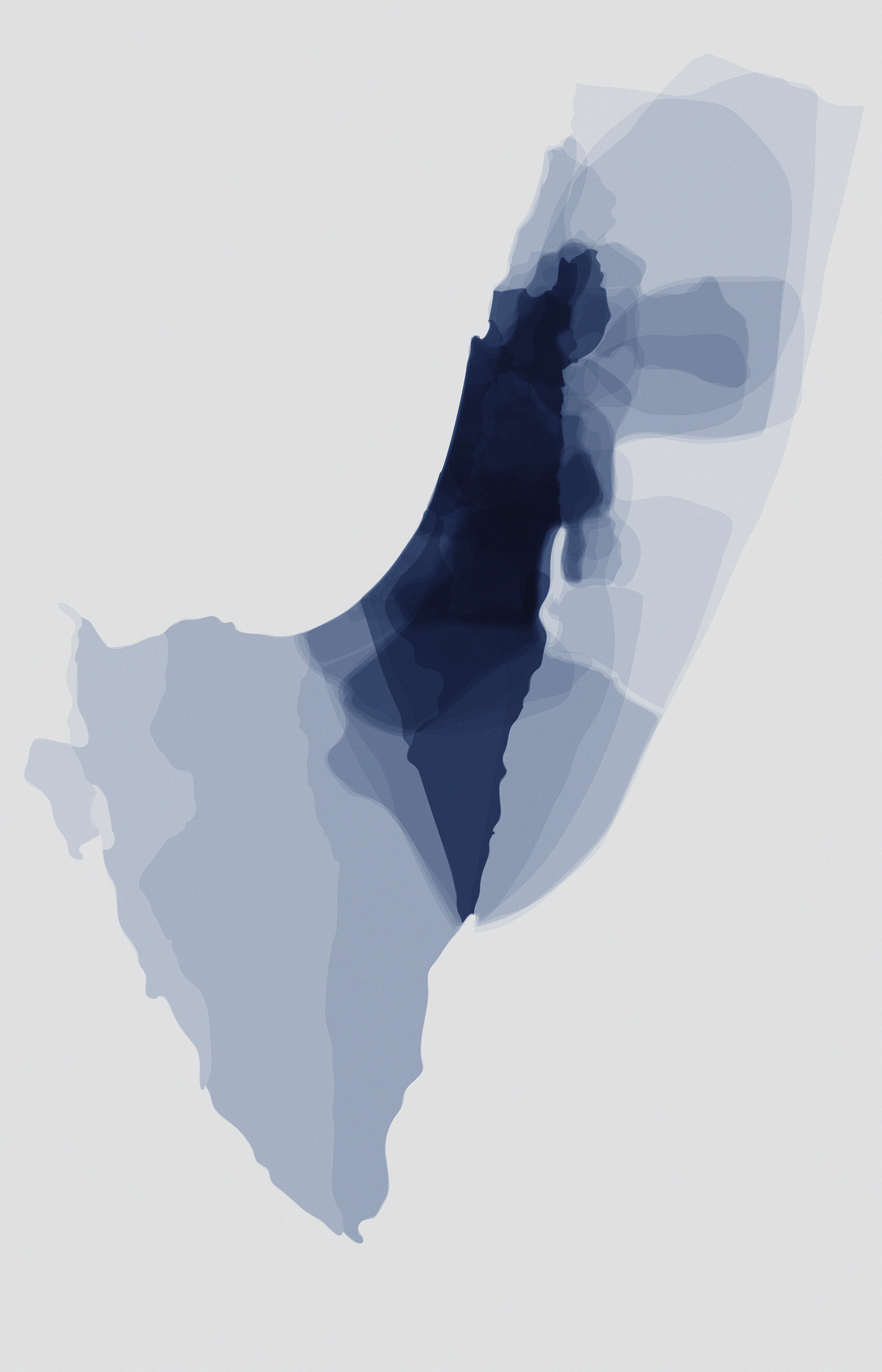
Overlapping border fluctuations Israel, Palestine from 1040 BCE to present day from Atlas of the Conflict: Israel-Palestine by Malkit Shoshan (010 Publishers. Rotterdam: 2010).
MALKIT SHOSHAN (Lecturer in Urban Planning and Design, Harvard Graduate School of Design)
Borders shape and consolidate relations between states, people, jurisdictions, political entities, and territories. They are tools entangled in complex sociopolitical and economic ecologies. While some borders are relatively stable, others are in a constant flow. They regulate economic relations and access to places, resources, and rights. Borders determine the way our surroundings are organized, inhabited and controlled, and the ways communities relate to one another—while some break through borders to survive, others fence themselves off.
The postcolonial borders of the twentieth century partitioned and shaped emerging nation-states, often on top of and without regard for existing communal and cultural entities, particularly in the Middle East and Africa. These borderlines were restructured and redefined time and again. Today the unprecedented forced movement of individuals and communities across borders—lawfully defined as refugees, asylum seekers, and migrants—ought to make us reconsider national borders as an apparatus of exclusion and open an inclusive debate about human rights and societal values of solidarity.
In the past years, the Foundation for Achieving Seamless Territory (FAST), an Amsterdam and New York-based architectural think-tank, developed various research and design projects on the intersection of architecture, spatial planning and human rights in conflict and post-conflict areas, amongst others, in Israel and Palestine. As one country emerges and the other disappears, spatial organizations of inclusion and exclusion are emblematically manifested in the shaping of the landscape and people’s livelihood. Moreover, the national borderline of Israel doesn’t consist of one continuous line, but multiple and overlying demarcation efforts to split, grab and control land, as well as natural, cultural and strategic resources.
The two accompanying images present border-conditions in two scales and time-lapses: a first map at a national scale depicts the overlapping borders of key territorial transitions in history; the second map offers a single time-frame that zooms into the current blockage of the Gaza Strip.
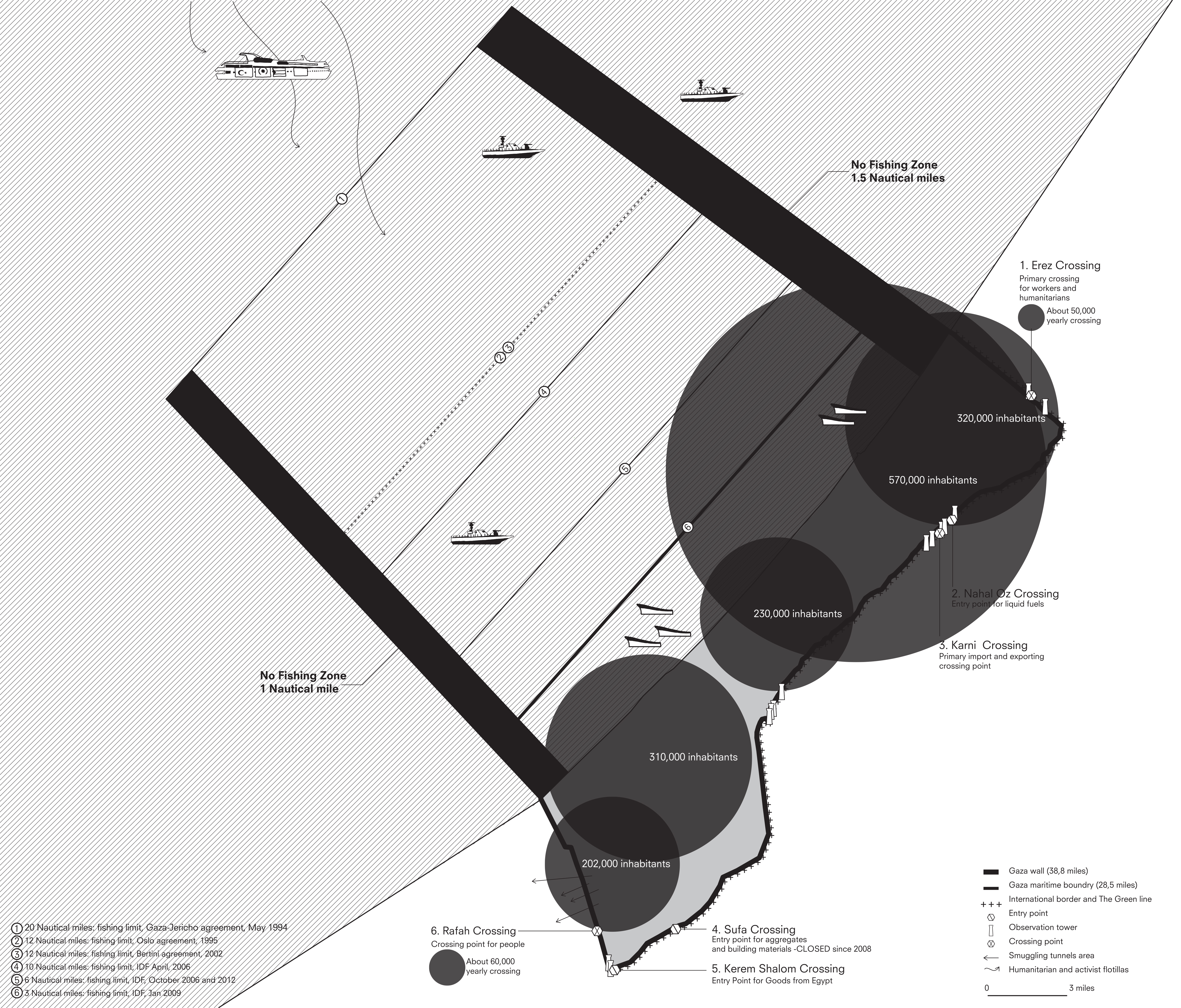
The Borders of the Gaza Strip by Malkit Shoshan/FAST: Foundation for Achieving Seamless Territory, from Zoo, or the letter Z, just after Zionism (NAiM/BureauEuropa. Maastricht, 2012).
1. Israel – Palestine
The State of Israel has no fixed and undisputed borders. From the moment it was established in 1948, Israel’s frontiers have been in perpetual flux, annexing, separating, isolating, and dividing territories. Ceasefire lines, international treaty demarcations, withdrawal zones and security barriers have all left their marks on the land. The absence of official borders and the presence of so many unofficial ones has generated a unique spatial condition, whereby the state is compelled to keep inventing ways to guard its territory. As a result, borders are internalized: small as well as large areas of land are either fenced in, or fenced out.
2. Gaza
The Gaza Strip is surrounded by a 25-foot-high barrier that runs along 38.8 miles of land and includes six crossing points. Continuous military surveillance throughout its 12-miles-long coastline is imposed by warships and drones. The Gaza airport is shuttered and its airspace is restricted. The Gaza Strip, a territory of 141 square miles, is the home of 1.85 million Palestinians that have been trapped inside hermetically controlled borders since 2005.