Borderless
Contributor
Basin&Range
Matthew Wagstaffe, YSOA M.Arch 1, 2019 is an editor of
Perspecta 55, which will investigate the relationship between architecture and forecasting technologies.
As the world’s nations continue to stumble over one another, falling out-of-step but steadily onwards towards a shared destination of environmental collapse, the call of this Paprika! rings loud and true: it certainly is high time we pay less heed to the oftentimes arbitrary nation-state borders that demarcate the globe’s surface and instead start designing in relation to the natural systems whose functioning is far more important to sustaining life on this planet.
That being said, it is important to pay attention to the fact that these natural systems don’t announce themselves of their own accord; there must be entire networks of expertise and sensory apparatuses in place before we can even perceive a watershed, let alone a truly borderless phenomenon like the atmosphere. And as any topologist knows, networks, though more labile than the rigid blocks of the Westphalian order, aren’t lacking for their own strains and tensions. Indeed, one of the central paradoxes uncovered in The Weather Machine, Andrew Blum’s pop science opus about the meteorological industry, is that despite requiring an international coalition of researchers and institutions the post-borders network of atmospheric scientists produces its own unique imbalances and fault-lines. So while the map of this industry looks radically different than our everyday one of nation-states, Blum’s surveying eye finds the same familiar cartographic features, merely re-assigned: atmospheric science still has its capitals (not London but Reading, where the Centre for Medium Range Weather Forecasts is located), its steep changes of grade (between technoscientifically advanced institutions and those that rely on their know-how), and even what looks a lot like territorial boundaries (here the line that matters most is between non-profit institutions, which have a mandate to share knowledge, and private companies like the nano satellite experts Spire, which have a propriety hold on the data they collect and so may offer their life-saving forecasts at an expensive premium). In other words, even while doing the good work of jettisoning state lines to study that ultimate free-flowing natural system, the atmosphere, pesky borders still find a way of coming into being.
One pressing task for architects, then, becomes the mapping of the new topographies and divisions of natural-systems knowledge networks, the better to understand the hidden blockades and leverage points that can help or hinder our environmental designs in the years to come. Of course, I have no map of this new world myself, but, ever the hoarder, I have collected a number of curious artifacts from my research forays into the complex knowledge communities underlying our post-national-borders order. In displaying them here, I will hopefully put some cairns in place to help fellow travelers as they continue to chart this novel territory.
Artifact 1: TIROS-1
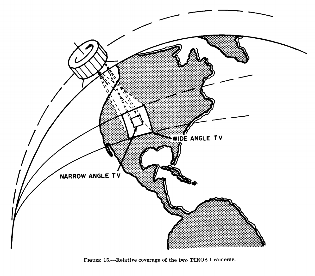
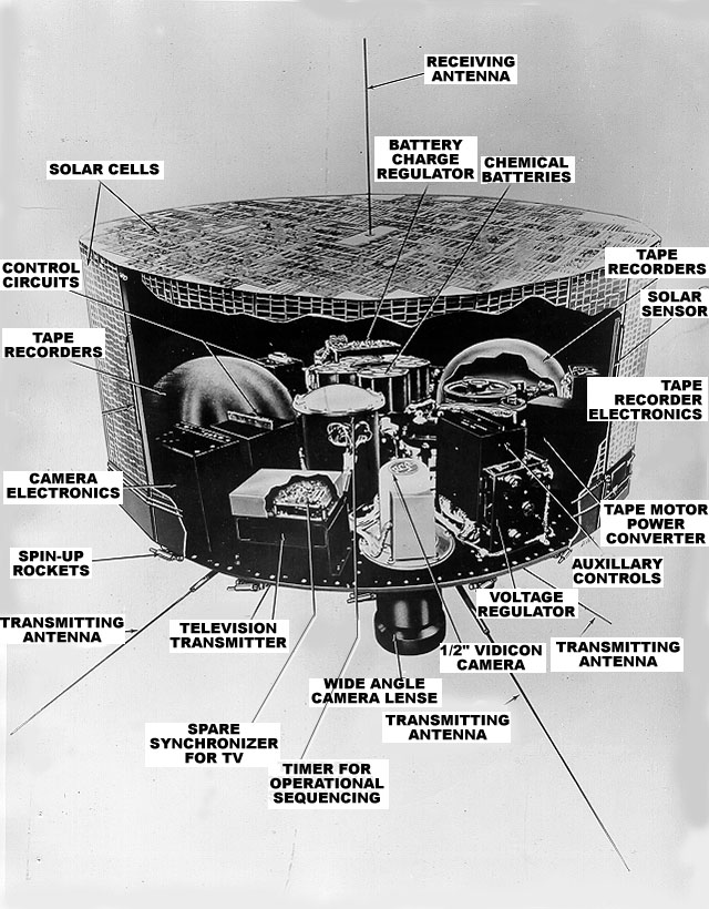
During the same 1961 speech in which Kennedy famously pledged to land a man on the moon, he also called for the funding of a world-wide system of weather observation satellites. The progenitor of the latter ambition was TIROS-1, the first satellite dedicated exclusively to studying the atmosphere, launched the year before. While the space program and its resulting Blue Marble photograph get all the credit for laying out the existential stakes of planetary life, it’s not hard to argue for TIROS-1 as the more prototypical example of a natural-systems-observation-technology: it’s a moving nodal point that traverses borders to produce knowledge of the (borderless) atmosphere—knowledge that will only get more precise with the subsequent launching of an entire network of similar observation devices. The diagram is clear: TIROS-1 and its network architecture lays waste to our national borders past. However, in reality, a weather satellite is much more than its geometric abstraction: what gets graphed as a single nodal point is in actuality a complex of highly sophisticated technical devices [Image1], each of which were manufactured by a different Cold War heavy hitter, from NASA to Lockheed Martin. With the eclipse of national borders, then, comes the aforementioned rise of new imbalances: the gatekeepers of the weather-observation system are the advanced technological institutions capable of building its constituent parts.
Finally, over-and-above these human institutions is the new boundary dictated by the object itself. In a telling illustration of TIROS-1 in action [Image 2], national borders have been absented to better accentuate the lines that really matter: the bounding box demarcating the satellite’s vision. It’s not just nations that are made irrelevant, but humans too—the technological object’s observing capacity draws the borders now.
Artifact 2: Waffle House Index
The fast-casual dining chain Waffle House advertises itself as offering “an unbeatable combination of good food with outstanding service.” While their culinary chops can be debated, it’s undeniable that their service—at least measured in terms of steadfastness in the face of adversity—is truly outstanding. Primarily located in hurricane-prone regions, the company deploys a sophisticated disaster planning and continuity team, enabling them to remain open even in the face of serious catastrophes. Their ability to withstand disasters is so renowned that our own FEMA regards the functioning of an area’s Waffle House’s as a highly accurate indicator of the severity of a given storm: alongside familiar metrics like hurricane wind-speed, the agency consults Waffle Houses status—open, green; limited menu, yellow; closed, red-alert—to help them predict how much aid a recovering community may require [Image 3].
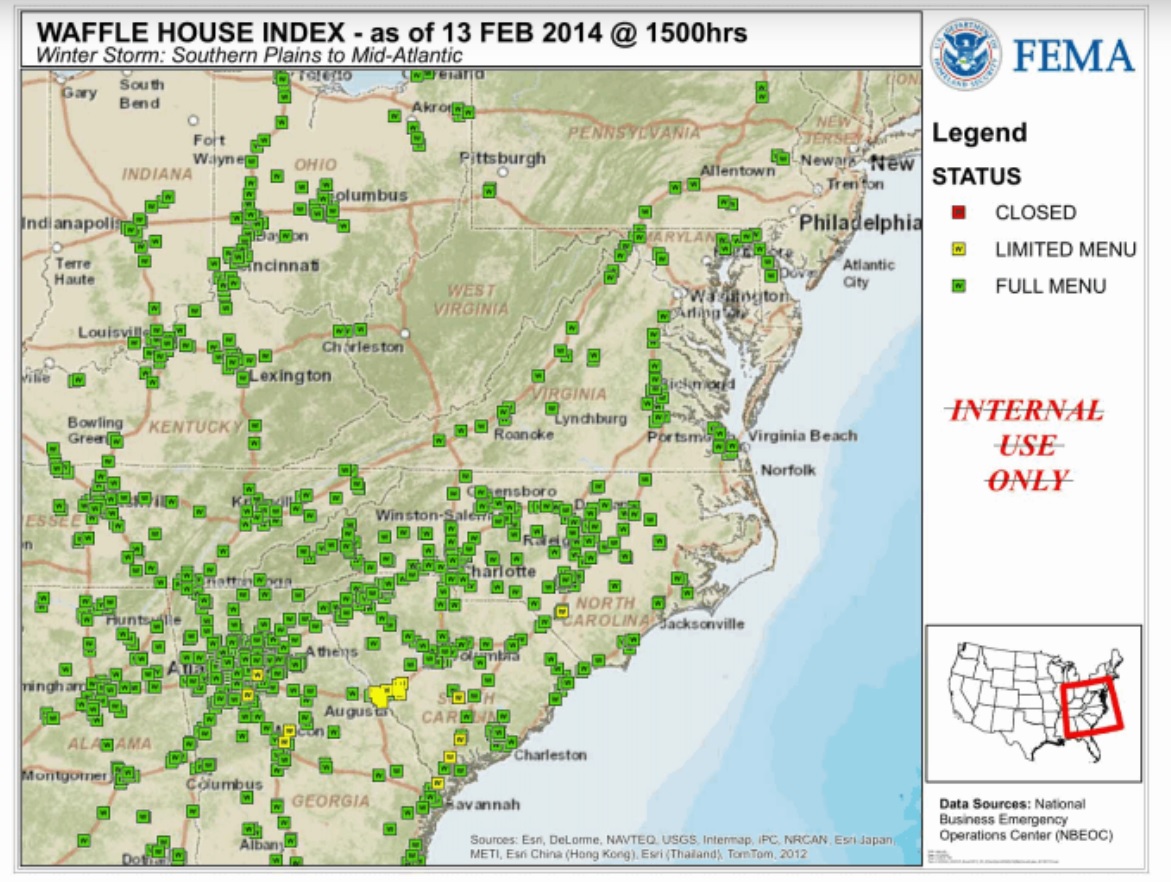
And so, lest we think that international coalitions of scientists are the sole cartographers of natural systems, along comes Waffle House to show us the often bizarre knowledge networks that come into being to chart a cross-borders problem like hurricanes. Who would’ve thought that the disaster planning experts responsible for keeping pancake supply chains up and running would inadvertently advise a government agency. When it comes to charting natural-systems, apparently the difference-maker can be something as seemingly arbitrary as a fast food company’s market extents.
Artifact 3: RMS(one) brochure
In 2014, the catastrophe modeling company Risk Management Solutions launched RMS(one), a digital platform that collates numerous risk models into one overarching global dataset, allowing its users to see, in real time, the likelihood of a variety of different disasters occurring anywhere on the planet. In their brochure advertising the product, RMS produced a world map of startling novelty: other than a demarcation of broad regions via color, the map ignores boundaries completely and instead renders landmasses as constitutions of identically sized hexagons [Image 4]. In this vision, national borders do not matter; instead the earth’s surface is broken up into equal quadrants of data where what is of import is a geographic unit’s likelihood of suffering a given disaster.
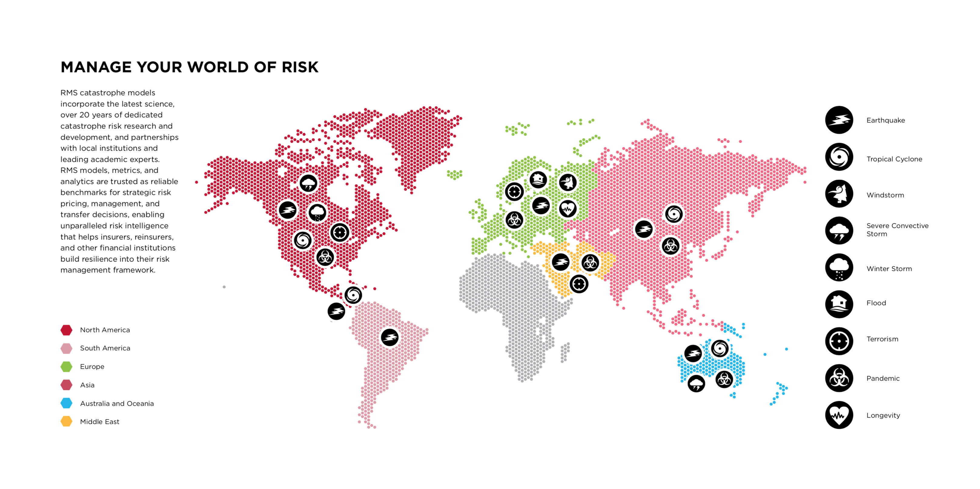
These disasters are likewise abstracted into exchangeable icons, for what matters to RMS(one)’s users are not the human and environmental costs of a catastrophe, but the financial ones. Importantly, RMS’s models calculate the potential insurance losses of a given disaster, allowing for the creation of a novel financial instrument called a “Catastrophe Bond”: investors agree to pay out the property loss claims that may accrue over a 3-5 year bond period with the understanding that, sans catastrophe, they will earn tremendous interest on their loan.
Our assumption that a deep engagement with the environment will force a confrontation with the particular physical properties and local conditions surrounding a given natural system is thereby turned on its head: by going even deeper, to discover the statistical laws that underlie catastrophes of all stripes, RMS(one)’s models instead abstract natural disasters to turn potential destruction into a statistics-based commodity that traders can invest or de-invest in to diversify their portfolios. National borders have been voided only to be replaced by the bell curve of a probability distribution, a line potentially even more destructive than the state boundaries of the recent past.
1 “Waffle House History,” Waffle House, https://www.wafflehouse.com/story/
2 Geographer Leigh Johnson has described Cat models as “the chief technologies creating tradable contingent futures” and provides a chilling example of the callous attitudes these abstractions give rise to when she quotes a fund manager’s description of his investing strategy as the mixing of “some Cal quake with a little Japan wind.” Leigh Johnson, “Catastrophe bonds and financial risk: Securing capital and rule through contingency,” Geoforum 45, DOI:10.1016/j.geoforum.2012.04.003